
daïra Tébessa topographic map
Interactive map
Click on the map to display elevation.
About this map
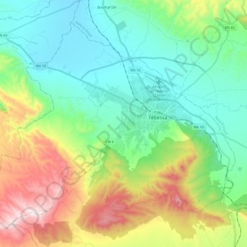
Name: daïra Tébessa topographic map, elevation, terrain.
Location: daïra Tébessa, Tébessa, 12000, Algérie (35.31940 7.95945 35.47764 8.19517)
Average elevation: 1,054 m
Minimum elevation: 770 m
Maximum elevation: 1,713 m
Other topographic maps
Click on a map to view its topography, its elevation and its terrain.
Tébessa
Algérie > Tébessa > daïra Tébessa
Tébessa, daïra Tébessa, Tébessa, 12000, Algérie
Average elevation: 1,030 m