
Montana City topographic map
Interactive map
Click on the map to display elevation.
About this map
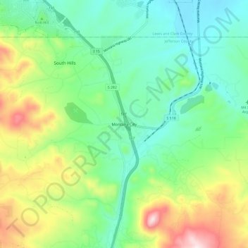
Name: Montana City topographic map, elevation, terrain.
Average elevation: 1,341 m
Minimum elevation: 1,189 m
Maximum elevation: 1,664 m
Other topographic maps
Click on a map to view its topography, its elevation and its terrain.
Clancy
United States > Montana > Jefferson County
Clancy, Jefferson County, Montana, 59638, United States
Average elevation: 1,370 m
Rice Motel and Trailer Court
United States > Montana > Jefferson County > Whitehall
Rice Motel and Trailer Court, Whitehall, Jefferson County, Montana, United States
Average elevation: 1,338 m
Welch
United States > Montana > Jefferson County
Welch, Jefferson County, Montana, United States
Average elevation: 1,710 m
Boulder River
United States > Montana > Jefferson County > Boulder
Boulder River, Boulder, Jefferson County, Montana, 59631, United States
Average elevation: 1,966 m
Mount Pisgah
United States > Montana > Jefferson County
Mount Pisgah, Jefferson County, Montana, United States
Average elevation: 2,265 m
Ringing Rocks
United States > Montana > Jefferson County
Ringing Rocks, Jefferson County, Montana, United States
Average elevation: 1,702 m
Whitehall
United States > Montana > Jefferson County
Whitehall, Jefferson County, Montana, United States
Average elevation: 1,336 m