
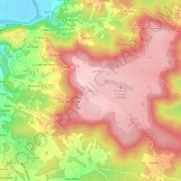
L'Île topographic map
Interactive map
Click on the map to display elevation.
About this map
Name: L'Île topographic map, elevation, terrain.
Average elevation: 215 m
Minimum elevation: 69 m
Maximum elevation: 304 m
Other topographic maps
Click on a map to view its topography, its elevation and its terrain.
Le Brat
France > Nouvelle-Aquitaine > Dordogne > Domme
Le Brat, Domme, Sarlat-la-Canéda, Dordogne, Nouvelle-Aquitaine, France métropolitaine, 24250, France
Average elevation: 124 m
Le Port
France > Nouvelle-Aquitaine > Dordogne > Domme
Le Port, Domme, Sarlat-la-Canéda, Dordogne, Nouvelle-Aquitaine, France métropolitaine, 24250, France
Average elevation: 127 m
Le Péparai
France > Nouvelle-Aquitaine > Dordogne > Domme
Le Péparai, Domme, Sarlat-la-Canéda, Dordogne, Nouvelle-Aquitaine, France métropolitaine, 24250, France
Average elevation: 180 m