
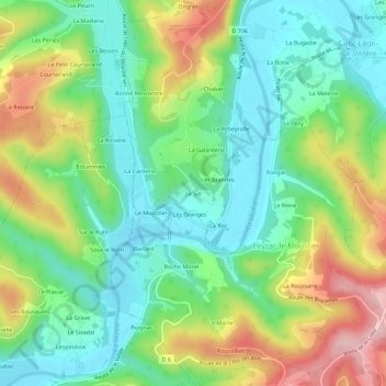
Le Sol topographic map
Interactive map
Click on the map to display elevation.
About this map
Name: Le Sol topographic map, elevation, terrain.
Average elevation: 133 m
Minimum elevation: 61 m
Maximum elevation: 261 m
Other topographic maps
Click on a map to view its topography, its elevation and its terrain.
Monbazillac
France > Nouvelle-Aquitaine > Dordogne > Saint-Léon-sur-Vézère > Monbazillac
Monbazillac, Saint-Léon-sur-Vézère, Sarlat-la-Canéda, Dordogne, Nouvelle-Aquitaine, France métropolitaine, 24290, France
Average elevation: 126 m
Les Granges
France > Nouvelle-Aquitaine > Dordogne > Saint-Léon-sur-Vézère
Les Granges, Saint-Léon-sur-Vézère, Sarlat-la-Canéda, Dordogne, Nouvelle-Aquitaine, France métropolitaine, 24290, France
Average elevation: 128 m
La Maletie
France > Nouvelle-Aquitaine > Dordogne > Saint-Léon-sur-Vézère
La Maletie, Saint-Léon-sur-Vézère, Sarlat-la-Canéda, Dordogne, Nouvelle-Aquitaine, France métropolitaine, 24290, France
Average elevation: 132 m