
Thank you for supporting this site ❤️
Make a donation
Make a donation
Perea topographic map
Click on the map to display elevation.
Thank you for supporting this site ❤️
Make a donation
Make a donation
About this map
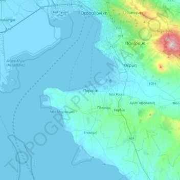
Name: Perea topographic map, elevation, terrain.
Average elevation: 90 m
Minimum elevation: -5 m
Maximum elevation: 1,178 m
Thank you for supporting this site ❤️
Make a donation
Make a donation
Other topographic maps
Click on a map to view its topography, its elevation and its terrain.
Neapoli Municipal Unit
Greece > Central Macedonia > Thessaloniki Regional Unit
Average elevation: 72 m
Stavroupoli Municipal Unit
Greece > Central Macedonia > Thessaloniki Regional Unit
Average elevation: 60 m
Neapoli Municipal Unit
Greece > Central Macedonia > Thessaloniki Regional Unit
Average elevation: 72 m
Thessaloniki Municipal Unit
Greece > Central Macedonia > Thessaloniki Regional Unit
Average elevation: 85 m
Thank you for supporting this site ❤️
Make a donation
Make a donation