
Blanchefort topographic map
Interactive map
Click on the map to display elevation.
About this map
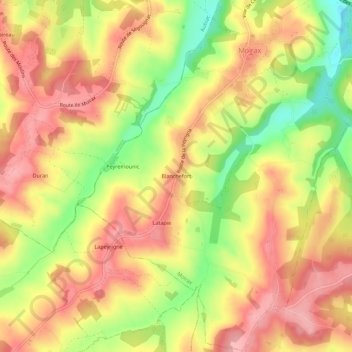
Name: Blanchefort topographic map, elevation, terrain.
Average elevation: 133 m
Minimum elevation: 59 m
Maximum elevation: 182 m
Other topographic maps
Click on a map to view its topography, its elevation and its terrain.
Latapie
France > Nouvelle-Aquitaine > Lot-et-Garonne > Moirax > Latapie
Latapie, Moirax, Agen, Lot-et-Garonne, Nouvelle-Aquitaine, France métropolitaine, 47310, France
Average elevation: 137 m