
Make a donation
Ungaran topographic map
Click on the map to display elevation.
Make a donation
Ungaran
Ungaran (Dutch: Oengaran) is a town and adjacent areas in Central Java Province of Indonesia. The town serves as the administrative centre of the Semarang Regency in that province. Ungaran is located at -7° 8' 17", 110° 24' 18" at an elevation of 319 metres. It encompasses two districts (kecamatan) within the Regency - Ungaran Barat (West Ungaran) covering 35.96 km2 with a population of 82,815 in 2024, and Ungaran Timur (East Ungaran) covering 37.99 km2 with a population of 83,610 in 2024.
Make a donation
About this map
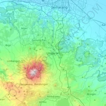
Name: Ungaran topographic map, elevation, terrain.
Average elevation: 399 m
Minimum elevation: 78 m
Maximum elevation: 1,558 m
Make a donation
Other topographic maps
Click on a map to view its topography, its elevation and its terrain.
Alun-Alun Ambarawa
Indonesia > Central Java > Kabupaten Semarang > Tambakboyo > Katang
Average elevation: 499 m