
городское поселение Алдан topographic map
Interactive map
Click on the map to display elevation.
About this map
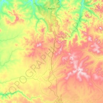
Name: городское поселение Алдан topographic map, elevation, terrain.
Average elevation: 873 m
Minimum elevation: 437 m
Maximum elevation: 1,579 m
Other topographic maps
Click on a map to view its topography, its elevation and its terrain.
Алдан
Russie > République de Sakha > Алданский улус > Алдан
Алдан, городское поселение Алдан, Алданский улус, République de Sakha, District fédéral extrême-oriental, 678900, Russie
Average elevation: 679 m