
Thank you for supporting this site ❤️
Make a donation
Make a donation
Gray topographic map
Click on the map to display elevation.
Thank you for supporting this site ❤️
Make a donation
Make a donation
About this map
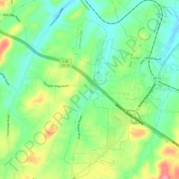
Name: Gray topographic map, elevation, terrain.
Average elevation: 477 m
Minimum elevation: 440 m
Maximum elevation: 539 m
Thank you for supporting this site ❤️
Make a donation
Make a donation
Other topographic maps
Click on a map to view its topography, its elevation and its terrain.
Thank you for supporting this site ❤️
Make a donation
Make a donation
Thank you for supporting this site ❤️
Make a donation
Make a donation
Greenfield Heights
United States > Tennessee > Washington County > Johnson City
Average elevation: 499 m
Montcastle Hills
United States > Tennessee > Washington County > Johnson City
Average elevation: 506 m
Thank you for supporting this site ❤️
Make a donation
Make a donation
East Ridge
United States > Tennessee > Washington County > Johnson City > East Ridge
Average elevation: 509 m
Thank you for supporting this site ❤️
Make a donation
Make a donation
Carnegie
United States > Tennessee > Washington County > Johnson City > Carnegie
Average elevation: 505 m