
Thank you for supporting this site ❤️
Make a donation
Make a donation
Rosmeer topographic map
Click on the map to display elevation.
Thank you for supporting this site ❤️
Make a donation
Make a donation
About this map
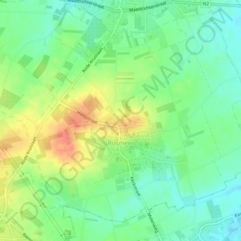
Name: Rosmeer topographic map, elevation, terrain.
Location: Rosmeer, Bilzen-Hoeselt, Tongeren, Limburg, Flanders, Belgium (50.83698 5.55753 50.85963 5.59993)
Average elevation: 98 m
Minimum elevation: 78 m
Maximum elevation: 129 m
Thank you for supporting this site ❤️
Make a donation
Make a donation
Other topographic maps
Click on a map to view its topography, its elevation and its terrain.