
Thank you for supporting this site ❤️
Make a donation
Make a donation
Montargil topographic map
Click on the map to display elevation.
Thank you for supporting this site ❤️
Make a donation
Make a donation
About this map
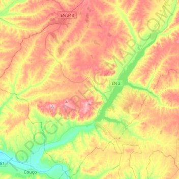
Name: Montargil topographic map, elevation, terrain.
Location: Montargil, Ponte de Sor, Portalegre, Portugal (38.97822 -8.31003 39.21306 -8.03314)
Average elevation: 128 m
Minimum elevation: 24 m
Maximum elevation: 237 m
Thank you for supporting this site ❤️
Make a donation
Make a donation
Other topographic maps
Click on a map to view its topography, its elevation and its terrain.
Barragens dos Estramontas
Portugal > Portalegre > Ponte de Sor > Foros do Arrão
Average elevation: 151 m
Thank you for supporting this site ❤️
Make a donation
Make a donation