
City of Oswego topographic map
Interactive map
Click on the map to display elevation.
About this map
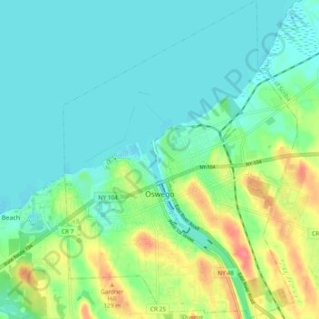
Name: City of Oswego topographic map, elevation, terrain.
Average elevation: 87 m
Minimum elevation: 70 m
Maximum elevation: 132 m
Oswego is located on the southeastern shore of Lake Ontario at the mouth of the Oswego River, approximately 35 miles north of Syracuse and 69 miles east of Rochester. The elevation is 298 feet above sea level. The nearest city is Fulton, located south of Oswego and north of Syracuse.
Other topographic maps
Click on a map to view its topography, its elevation and its terrain.
City of Fulton
United States > New York > Oswego County
City of Fulton, Oswego County, New York, 13069, United States
Average elevation: 114 m
Lansing
United States > New York > Oswego County
Lansing, Town of Scriba, Oswego County, New York, 13126, United States
Average elevation: 115 m
Union Settlement
United States > New York > Oswego County > Town of West Monroe
Union Settlement, Town of West Monroe, Oswego County, New York, 13167, United States
Average elevation: 153 m
Altmar
United States > New York > Oswego County
Altmar, Town of Albion, Oswego County, New York, United States
Average elevation: 175 m
Town of Orwell
United States > New York > Oswego County
Town of Orwell, Albion, Oswego County, New York, United States
Average elevation: 227 m
Town of Palermo
United States > New York > Oswego County
Town of Palermo, Oswego County, New York, United States
Average elevation: 134 m
Town of Mexico
United States > New York > Oswego County
Town of Mexico, Oswego County, New York, 13114, United States
Average elevation: 119 m
Colosse
United States > New York > Oswego County > Town of Mexico
Colosse, Town of Mexico, Albion, Oswego County, New York, 13131, United States
Average elevation: 136 m
Village of Phoenix
United States > New York > Oswego County > Town of Schroeppel
Village of Phoenix, Town of Schroeppel, Oswego County, New York, United States
Average elevation: 117 m
Town of Redfield
United States > New York > Oswego County
Town of Redfield, Oswego County, New York, 13437, United States
Average elevation: 395 m
Town of Amboy
United States > New York > Oswego County
Town of Amboy, Oswego County, New York, United States
Average elevation: 194 m
Mud Hill
United States > New York > Oswego County > Town of Amboy
Mud Hill, Town of Amboy, Oswego County, New York, 13493, United States
Average elevation: 213 m
Redfield
United States > New York > Oswego County > Redfield
Redfield, Town of Redfield, Oswego County, New York, 13437, United States
Average elevation: 318 m
Fulton
United States > New York > Oswego County > Fulton
Fulton, Oswego County, New York, 13069-2934, United States
Average elevation: 121 m
Town of Albion
United States > New York > Oswego County
Town of Albion, Oswego County, New York, 13302, United States
Average elevation: 179 m
Oneida Lake
United States > New York > Oswego County > Town of Constantia
Oneida Lake, Town of Constantia, Town of Lenox, Oswego County, New York, United States
Average elevation: 138 m
Village of Parish
United States > New York > Oswego County > Town of Parish
Village of Parish, Town of Parish, Albion, Oswego County, New York, United States
Average elevation: 147 m
Village of Pulaski
United States > New York > Oswego County > Town of Richland > Village of Pulaski
Village of Pulaski, Town of Richland, Oswego County, New York, United States
Average elevation: 117 m