
Bethelridge topographic map
Interactive map
Click on the map to display elevation.
About this map
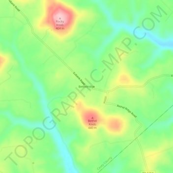
Name: Bethelridge topographic map, elevation, terrain.
Location: Bethelridge, Casey County, Kentucky, 42516, United States (37.21369 -84.77828 37.25369 -84.73828)
Average elevation: 344 m
Minimum elevation: 268 m
Maximum elevation: 463 m
Other topographic maps
Click on a map to view its topography, its elevation and its terrain.
Dunnville
United States > Kentucky > Casey County
Dunnville, Casey County, Kentucky, 42528, United States
Average elevation: 246 m
Windsor
United States > Kentucky > Casey County
Windsor, Casey County, Kentucky, 42565, United States
Average elevation: 336 m
Middleburg
United States > Kentucky > Casey County
Middleburg, Casey County, Kentucky, 42541, United States
Average elevation: 287 m
Gordon Lick Knob
United States > Kentucky > Casey County
Gordon Lick Knob, Casey County, Kentucky, United States
Average elevation: 356 m
Creston
United States > Kentucky > Casey County
Creston, Casey County, Kentucky, United States
Average elevation: 312 m
Yosemite
United States > Kentucky > Casey County
Yosemite, Casey County, Kentucky, 42541, United States
Average elevation: 285 m