
Rhinecliff topographic map
Interactive map
Click on the map to display elevation.
About this map
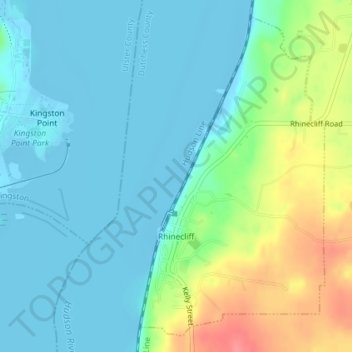
Name: Rhinecliff topographic map, elevation, terrain.
Average elevation: 19 m
Minimum elevation: -9 m
Maximum elevation: 73 m
The hamlet is demarcated by large agricultural and wooded area to the north, east, and south, and bounded by the Hudson River on the west. Steep topography, formed by contorted slate ridges and valleys, define the site-specific and seemingly random orientation of the small, frame nineteenth-century houses and winding narrow roads. The hamlet had a mid-nineteenth century building boom, but its boundaries and building density have changed very little over the last one hundred years.
Other topographic maps
Click on a map to view its topography, its elevation and its terrain.
Drayton Grant Park at Burger Hill
United States > New York > Dutchess County > Town of Rhinebeck
Drayton Grant Park at Burger Hill, Town of Rhinebeck, Dutchess County, New York, United States
Average elevation: 102 m