
Oberstaufen topographic map
Interactive map
Click on the map to display elevation.
About this map
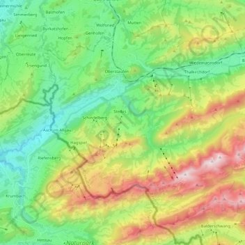
Name: Oberstaufen topographic map, elevation, terrain.
Location: Oberstaufen, Landkreis Oberallgäu, Bavière, 87534, Allemagne (47.46563 9.95842 47.58342 10.16510)
Average elevation: 983 m
Minimum elevation: 552 m
Maximum elevation: 1,818 m
Other topographic maps
Click on a map to view its topography, its elevation and its terrain.
Kalzhofen
Allemagne > Bavière > Landkreis Oberallgäu > Oberstaufen
Kalzhofen, Oberstaufen, Landkreis Oberallgäu, Bavière, 87534, Allemagne
Average elevation: 851 m