
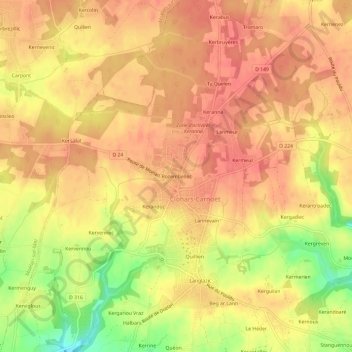
Rozembellec topographic map
Interactive map
Click on the map to display elevation.
About this map
Name: Rozembellec topographic map, elevation, terrain.
Average elevation: 50 m
Minimum elevation: 7 m
Maximum elevation: 68 m
Other topographic maps
Click on a map to view its topography, its elevation and its terrain.
La Laïta
France > Bretagne > Finistère > Clohars-Carnoët
La Laïta, Clohars-Carnoët, Quimper, Finistère, Bretagne, France métropolitaine, 29360, France
Average elevation: 45 m
Doelan
France > Bretagne > Finistère > Clohars-Carnoët
Doelan, Clohars-Carnoët, Quimper, Finistère, Bretagne, France métropolitaine, 29360, France
Average elevation: 17 m
Pont Doelan
France > Bretagne > Finistère > Clohars-Carnoët > Pont Doelan
Pont Doelan, Clohars-Carnoët, Quimper, Finistère, Bretagne, France métropolitaine, 29360, France
Average elevation: 18 m
Menhir de l'Eglise
France > Bretagne > Finistère > Clohars-Carnoët > Rozembellec
Menhir de l'Eglise, Chemin du Presbytère, Keranguen, Rozembellec, Clohars-Carnoët, Quimper, Finistère, Bretagne, France métropolitaine, 29360, France
Average elevation: 52 m
Keruster
France > Bretagne > Finistère > Clohars-Carnoët
Keruster, Clohars-Carnoët, Quimper, Finistère, Bretagne, France métropolitaine, 29360, France
Average elevation: 19 m
Petit Lety
France > Bretagne > Finistère > Clohars-Carnoët
Petit Lety, Clohars-Carnoët, Quimper, Finistère, Bretagne, France métropolitaine, 29360, France
Average elevation: 50 m
Lannevain
France > Bretagne > Finistère > Clohars-Carnoët
Lannevain, Clohars-Carnoët, Quimper, Finistère, Bretagne, France métropolitaine, 29360, France
Average elevation: 47 m
Parcou Tal Ar Vilin
France > Bretagne > Finistère > Clohars-Carnoët
Parcou Tal Ar Vilin, Clohars-Carnoët, Quimper, Finistère, Bretagne, France métropolitaine, 29360, France
Average elevation: 15 m
Kergantine
France > Bretagne > Finistère > Clohars-Carnoët
Kergantine, Clohars-Carnoët, Quimper, Finistère, Bretagne, France métropolitaine, 29360, France
Average elevation: 24 m