
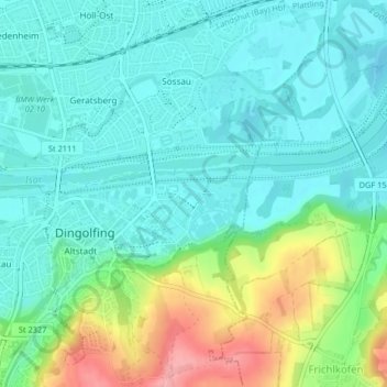
Zirkuswiese topographic map
Interactive map
Click on the map to display elevation.
About this map
Name: Zirkuswiese topographic map, elevation, terrain.
Average elevation: 377 m
Minimum elevation: 346 m
Maximum elevation: 461 m
Other topographic maps
Click on a map to view its topography, its elevation and its terrain.
Mietzing
Deutschland > Bayern > Landkreis Dingolfing-Landau > Dingolfing > Schermau
Mietzing, Schermau, Dingolfing, Landkreis Dingolfing-Landau, Bayern, 84180, Deutschland
Average elevation: 458 m
Teisbach
Deutschland > Bayern > Landkreis Dingolfing-Landau > Dingolfing
Teisbach, Dingolfing, Landkreis Dingolfing-Landau, Bayern, 84180, Deutschland
Average elevation: 398 m
Weinpreß
Deutschland > Bayern > Landkreis Dingolfing-Landau > Dingolfing > Teisbach
Weinpreß, Teisbach, Dingolfing, Landkreis Dingolfing-Landau, Bayern, 84130, Deutschland
Average elevation: 399 m