
Hocking Hills State Park topographic map
Interactive map
Click on the map to display elevation.
About this map
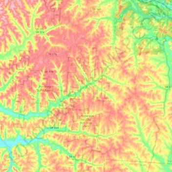
Name: Hocking Hills State Park topographic map, elevation, terrain.
Average elevation: 292 m
Minimum elevation: 202 m
Maximum elevation: 365 m
Other topographic maps
Click on a map to view its topography, its elevation and its terrain.
Union Furnace
United States > Ohio > Hocking County
Union Furnace, Hocking County, Ohio, 43158, United States
Average elevation: 268 m
Monday
United States > Ohio > Hocking County
Monday, Hocking County, Ohio, 43247, United States
Average elevation: 260 m
Old Gore
United States > Ohio > Hocking County
Old Gore, Hocking County, Ohio, 43111, United States
Average elevation: 259 m
Ewing
United States > Ohio > Hocking County
Ewing, Hocking County, Ohio, United States
Average elevation: 278 m
Enterprise
United States > Ohio > Hocking County
Enterprise, Hocking County, Ohio, United States
Average elevation: 257 m
Buena Vista
United States > Ohio > Hocking County
Buena Vista, Hocking County, Ohio, United States
Average elevation: 314 m
West Logan
United States > Ohio > Hocking County
West Logan, Hocking County, Ohio, 43138, United States
Average elevation: 248 m
Haydenville
United States > Ohio > Hocking County
Haydenville, Hocking County, Ohio, 43127, United States
Average elevation: 250 m
Carbon Hill
United States > Ohio > Hocking County
Carbon Hill, Hocking County, Ohio, 43247, United States
Average elevation: 256 m
Murray City
United States > Ohio > Hocking County
Murray City, Hocking County, Ohio, 43144, United States
Average elevation: 257 m
Gibisonville
United States > Ohio > Hocking County
Gibisonville, Hocking County, Ohio, United States
Average elevation: 321 m
Greendale
United States > Ohio > Hocking County
Greendale, Hocking County, Ohio, 43111, United States
Average elevation: 249 m
Gore
United States > Ohio > Hocking County
Gore, Hocking County, Ohio, 43766, United States
Average elevation: 259 m
Jobs
United States > Ohio > Hocking County
Jobs, Hocking County, Ohio, 43144, United States
Average elevation: 259 m
Haynes
United States > Ohio > Hocking County
Haynes, Hocking County, Ohio, United States
Average elevation: 255 m
Orbiston
United States > Ohio > Hocking County
Orbiston, Hocking County, Ohio, 43144, United States
Average elevation: 256 m
Longstreth
United States > Ohio > Hocking County
Longstreth, Hocking County, Ohio, 43247, United States
Average elevation: 261 m
Starr
United States > Ohio > Hocking County
Starr, Hocking County, Ohio, 45654, United States
Average elevation: 273 m
Sand Run
United States > Ohio > Hocking County
Sand Run, Hocking County, Ohio, 43247, United States
Average elevation: 257 m
Webb Summit
United States > Ohio > Hocking County
Webb Summit, Hocking County, Ohio, United States
Average elevation: 270 m
Rockbridge
United States > Ohio > Hocking County
Rockbridge, Hocking County, Ohio, 43149, United States
Average elevation: 262 m
Logan
United States > Ohio > Hocking County
Logan, Hocking County, Ohio, 43138, United States
Average elevation: 254 m
South Bloomingville
United States > Ohio > Hocking County
South Bloomingville, Hocking County, Ohio, 43152, United States
Average elevation: 270 m
Laurelville
United States > Ohio > Hocking County
Laurelville, Hocking County, Ohio, United States
Average elevation: 249 m
Ilesboro
United States > Ohio > Hocking County
Ilesboro, Hocking County, Ohio, United States
Average elevation: 291 m