
Make a donation
Cooum topographic map
Click on the map to display elevation.
Make a donation
About this map
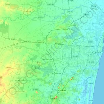
Name: Cooum topographic map, elevation, terrain.
Average elevation: 27 m
Minimum elevation: -1 m
Maximum elevation: 158 m
Make a donation
Other topographic maps
Click on a map to view its topography, its elevation and its terrain.
Avadi
India > Tamil Nadu > Poonamallee
Avadi is located at 13°07′N 80°06′E / 13.12°N 80.1°E / 13.12; 80.1. It covers an area of 65 square kilometres (25 sq mi) and has an average elevation of 17 metres (56 ft).
Average elevation: 23 m
Make a donation
Make a donation
Make a donation
Make a donation
Avadi
India > Tamil Nadu > Poonamallee
Avadi is located at 13°07′N 80°06′E / 13.12°N 80.1°E / 13.12; 80.1. It covers an area of 65 square kilometres (25 sq mi) and has an average elevation of 17 metres (56 ft). Avadi is the one of the largest locality in Chennai, stretching from Poonamalle High Road to MTH Road.
Average elevation: 23 m
Make a donation
Avadi
India > Tamil Nadu > Poonamallee
Avadi is located at 13°07′N 80°06′E / 13.12°N 80.1°E / 13.12; 80.1. It covers an area of 65 square kilometres (25 sq mi) and has an average elevation of 17 metres (56 ft).
Average elevation: 23 m
Make a donation
Avadi
India > Tamil Nadu > Poonamallee
Avadi is located at 13°07′N 80°06′E / 13.12°N 80.1°E / 13.12; 80.1. It covers an area of 65 square kilometres (25 sq mi) and has an average elevation of 17 metres (56 ft). Avadi is one of the largest localities in Chennai, stretching from Poonamalle High Road to MTH Road.
Average elevation: 23 m
Make a donation