
Turtmannspitze topographic map
Interactive map
Click on the map to display elevation.
About this map
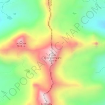
Name: Turtmannspitze topographic map, elevation, terrain.
Location: Turtmannspitze, Anniviers, Siders, Wallis, 3961, Schweiz (46.20432 7.66178 46.20442 7.66188)
Average elevation: 2,676 m
Minimum elevation: 2,367 m
Maximum elevation: 3,065 m
Other topographic maps
Click on a map to view its topography, its elevation and its terrain.
Zinalrothorn
Zinalrothorn, Anniviers, Siders, Wallis, 3961, Schweiz
Average elevation: 3,514 m