
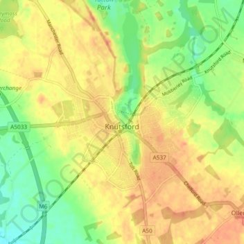
Knutsford topographic map
Interactive map
Click on the map to display elevation.
About this map
Name: Knutsford topographic map, elevation, terrain.
Location: Knutsford, Cheshire East, England, Vereinigtes Königreich (53.28683 -2.40610 53.31990 -2.33256)
Average elevation: 57 m
Minimum elevation: 33 m
Maximum elevation: 75 m
Other topographic maps
Click on a map to view its topography, its elevation and its terrain.
Kettleshulme
Vereinigtes Königreich > England > Cheshire East
Kettleshulme, Cheshire East, England, SK23 7QU, Vereinigtes Königreich
Average elevation: 296 m