
Municipal Unit of Nafplio topographic map
Interactive map
Click on the map to display elevation.
About this map
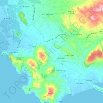
Name: Municipal Unit of Nafplio topographic map, elevation, terrain.
Average elevation: 76 m
Minimum elevation: -3 m
Maximum elevation: 398 m
Other topographic maps
Click on a map to view its topography, its elevation and its terrain.
Nafplio
Greece > Peloponnese, Western Greece and the Ionian > Argolis Regional Unit > Municipal Unit of Nafplio
Average elevation: 36 m