
BT topographic map
Interactive map
Click on the map to display elevation.
About this map
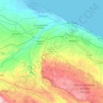
Name: BT topographic map, elevation, terrain.
Location: BT, Apúlia, Itália (40.89870 15.87109 41.44268 16.54200)
Average elevation: 218 m
Minimum elevation: -5 m
Maximum elevation: 811 m
Other topographic maps
Click on a map to view its topography, its elevation and its terrain.
Presicce-Acquarica
Presicce-Acquarica, Lecce, Apúlia, Itália
Average elevation: 123 m
Melendugno
Itália > Apúlia > Melendugno
Melendugno, Lecce, Apúlia, 73026, Italia
Average elevation: 38 m