
Sør-Odal topographic map
Interactive map
Click on the map to display elevation.
About this map
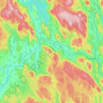
Name: Sør-Odal topographic map, elevation, terrain.
Location: Sør-Odal, Innlandet, Norway (60.04778 11.52034 60.37678 11.93719)
Average elevation: 251 m
Minimum elevation: 114 m
Maximum elevation: 529 m
Other topographic maps
Click on a map to view its topography, its elevation and its terrain.
Li
Norway > Innlandet > Skammestein
Li, Skammestein, Øystre Slidre, Innlandet, 2950, Norway
Average elevation: 774 m
Scandinavian Mountains
Scandinavian Mountains, Lom, Innlandet, Norway
Average elevation: 2,050 m
Fregn naturreservat
Fregn naturreservat, Trysil, Innlandet, Norway
Average elevation: 673 m
Viewpoint Snøhetta
Viewpoint Snøhetta, Vålåsjøhøvegen, Dovre, Innlandet, 2661, Norway
Average elevation: 1,157 m
Beitostølen
Beitostølen, Øystre Slidre, Innlandet, 2953, Norway
Average elevation: 914 m