
Vaughn topographic map
Interactive map
Click on the map to display elevation.
About this map
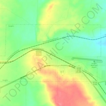
Name: Vaughn topographic map, elevation, terrain.
Location: Vaughn, Guadalupe County, New Mexico, 88353, United States (34.59434 -105.24312 34.62057 -105.18422)
Average elevation: 1,816 m
Minimum elevation: 1,782 m
Maximum elevation: 1,855 m
Other topographic maps
Click on a map to view its topography, its elevation and its terrain.
Tejon
United States > New Mexico > Guadalupe County
Tejon, Guadalupe County, New Mexico, United States
Average elevation: 1,861 m
Santa Rosa
United States > New Mexico > Guadalupe County
Santa Rosa, Guadalupe County, New Mexico, United States
Average elevation: 1,424 m
Cuervo
United States > New Mexico > Guadalupe County
Cuervo, Guadalupe County, New Mexico, United States
Average elevation: 1,502 m
Santa Rosa Lake State Park
United States > New Mexico > Guadalupe County
Santa Rosa Lake State Park, Guadalupe County, New Mexico, United States
Average elevation: 1,465 m