
Thank you for supporting this site ❤️
Make a donation
Make a donation
La Asunta topographic map
Click on the map to display elevation.
Thank you for supporting this site ❤️
Make a donation
Make a donation
About this map
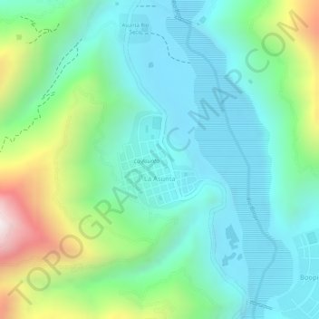
Name: La Asunta topographic map, elevation, terrain.
Average elevation: 865 m
Minimum elevation: 669 m
Maximum elevation: 1,367 m
Thank you for supporting this site ❤️
Make a donation
Make a donation
Other topographic maps
Click on a map to view its topography, its elevation and its terrain.
Villa Victoria
Bolivia > La Paz > Provincia Sud Yungas > Municipio La Asunta
Average elevation: 1,237 m