
Thank you for supporting this site ❤️
Make a donation
Make a donation
Pegões topographic map
Click on the map to display elevation.
Thank you for supporting this site ❤️
Make a donation
Make a donation
About this map
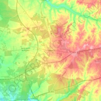
Name: Pegões topographic map, elevation, terrain.
Location: Pegões, Montijo, Setúbal, Portugal (38.64469 -8.78236 38.72197 -8.56621)
Average elevation: 77 m
Minimum elevation: 20 m
Maximum elevation: 135 m
Thank you for supporting this site ❤️
Make a donation
Make a donation
Other topographic maps
Click on a map to view its topography, its elevation and its terrain.
Thank you for supporting this site ❤️
Make a donation
Make a donation
Thank you for supporting this site ❤️
Make a donation
Make a donation
Thank you for supporting this site ❤️
Make a donation
Make a donation
Thank you for supporting this site ❤️
Make a donation
Make a donation
Charneca de Caparica
Portugal > Setúbal > Charneca de Caparica e Sobreda > Charneca de Caparica
Average elevation: 40 m
Thank you for supporting this site ❤️
Make a donation
Make a donation