
Thank you for supporting this site ❤️
Make a donation
Make a donation
Zhuolu County topographic map
Click on the map to display elevation.
Thank you for supporting this site ❤️
Make a donation
Make a donation
About this map
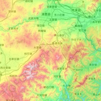
Name: Zhuolu County topographic map, elevation, terrain.
Location: Zhuolu County, Zhangjiakou, Hebei, China (39.67147 114.92252 40.49095 115.50665)
Average elevation: 1,036 m
Minimum elevation: 263 m
Maximum elevation: 2,832 m
Thank you for supporting this site ❤️
Make a donation
Make a donation
Other topographic maps
Click on a map to view its topography, its elevation and its terrain.