
Nauen topographic map
Interactive map
Click on the map to display elevation.
About this map
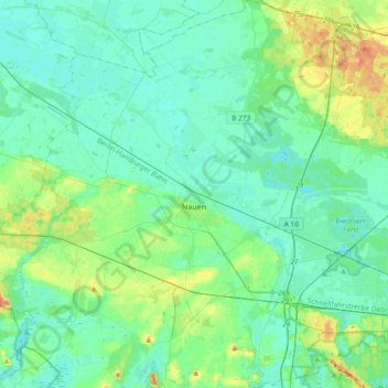
Name: Nauen topographic map, elevation, terrain.
Location: Nauen, Havelland, Brandenburg, Deutschland (52.50132 12.65240 52.72538 13.01349)
Average elevation: 36 m
Minimum elevation: 27 m
Maximum elevation: 67 m
Im Jahr 1869 erfolgte die Einweihung einer höheren Knabenschule.
Other topographic maps
Click on a map to view its topography, its elevation and its terrain.
Klein Behnitz
Deutschland > Brandenburg > Nauen
Klein Behnitz, Nauen, Havelland, Brandenburg, Deutschland
Average elevation: 43 m
Schloss Ribbeck
Deutschland > Brandenburg > Nauen > Ribbeck
Schloss Ribbeck, 10, Theodor-Fontane-Straße, Ribbeck, Nauen, Havelland, Brandenburg, 14641, Deutschland
Average elevation: 38 m