
Amanat Al Asimah topographic map
Interactive map
Click on the map to display elevation.
About this map
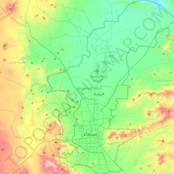
Name: Amanat Al Asimah topographic map, elevation, terrain.
Location: Amanat Al Asimah, Yemen (15.27553 44.12062 15.61171 44.39967)
Average elevation: 2,382 m
Minimum elevation: 2,050 m
Maximum elevation: 3,189 m
At an elevation of 2,300 metres (7,500 ft), Sanaa is one of the highest capital cities in the world and is next to the Sarawat Mountains of Jabal An-Nabi Shu'ayb and Jabal Tiyal, considered to be the highest mountains in the Arabian Peninsula and one of the highest in the region. Sanaa has a population of approximately 3,292,497 (2023), making it Yemen's largest city. As of 2020, the greater Sanaa urban area makes up about 10% of Yemen's total population.
Other topographic maps
Click on a map to view its topography, its elevation and its terrain.
Jabal `Ali
Jabal `Ali, Sanhan wa Bani Bahlool District, Sana'a Governorate, Yemen
Average elevation: 2,533 m
Al Ghayl district
Al Ghayl district, Al Jawf Governorate, Yemen
Average elevation: 1,189 m
Al Ghayl
Yemen > Al Jawf Governorate > Al Ghayl
Al Ghayl, Al Ghayl district, Al Jawf Governorate, Yemen
Average elevation: 1,139 m
Ad Dakhiliyah
Yemen > Hajjah Governorate > Al Qawd > Ad Dakhiliyah
Ad Dakhiliyah, Al Qawd, Wadhrah District, Hajjah Governorate, Yemen
Average elevation: 743 m
Tarim District
Tarim District, Hadramaut Governorate, Yemen
Average elevation: 879 m
Al Haymah ad Dakhiliyah
Yemen > Al Mahwit Governorate > Mabkar
Al Haymah ad Dakhiliyah, Ar Rujum District, Al Mahwit Governorate, Yemen
Average elevation: 1,256 m