
棉花冲 topographic map
Interactive map
Click on the map to display elevation.
About this map
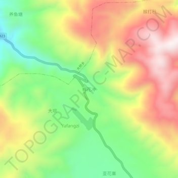
Name: 棉花冲 topographic map, elevation, terrain.
Location: 棉花冲, 石屏县, 红河哈尼族彝族自治州, 云南省, 中国 (23.79630 102.37600 23.83630 102.41600)
Average elevation: 1,610 m
Minimum elevation: 1,251 m
Maximum elevation: 2,007 m
Other topographic maps
Click on a map to view its topography, its elevation and its terrain.