
La Tourette topographic map
Interactive map
Click on the map to display elevation.
About this map
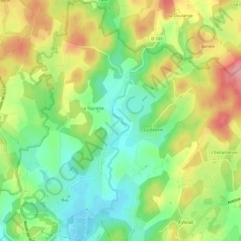
Name: La Tourette topographic map, elevation, terrain.
Average elevation: 677 m
Minimum elevation: 619 m
Maximum elevation: 753 m
Other topographic maps
Click on a map to view its topography, its elevation and its terrain.
Saint-Dézery
France > Nouvelle-Aquitaine > Corrèze > Ussel
Saint-Dézery, Ussel, Corrèze, Nouvelle-Aquitaine, France métropolitaine, 19200, France
Average elevation: 706 m
L'Ebraly de Saint-Dezery
France > Nouvelle-Aquitaine > Corrèze > Ussel
L'Ebraly de Saint-Dezery, Ussel, Corrèze, Nouvelle-Aquitaine, France métropolitaine, 19200, France
Average elevation: 713 m
Ponty
France > Nouvelle-Aquitaine > Corrèze > Ussel
Ponty, Ussel, Corrèze, Nouvelle-Aquitaine, France métropolitaine, 19200, France
Average elevation: 666 m
Saint-Dézery
France > Nouvelle-Aquitaine > Corrèze > Ussel
Saint-Dézery, Ussel, Corrèze, Nouvelle-Aquitaine, France métropolitaine, 19200, France
Average elevation: 704 m
La Tourette
France > Nouvelle-Aquitaine > Corrèze > Ussel
La Tourette, Ussel, Corrèze, Nouvelle-Aquitaine, France métropolitaine, 19200, France
Average elevation: 681 m