
Crugers topographic map
Interactive map
Click on the map to display elevation.
About this map
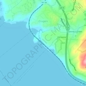
Name: Crugers topographic map, elevation, terrain.
Average elevation: 23 m
Minimum elevation: 0 m
Maximum elevation: 144 m
Other topographic maps
Click on a map to view its topography, its elevation and its terrain.
Crompond
United States > New York > Westchester County > Town of Cortlandt
Crompond, Town of Cortlandt, Westchester County, New York, 10517, United States
Average elevation: 131 m
Roe Park
United States > New York > Westchester County > Town of Cortlandt
Roe Park, Town of Cortlandt, Westchester County, New York, 10567, United States
Average elevation: 106 m
Pleasantside
United States > New York > Westchester County > Town of Cortlandt
Pleasantside, Town of Cortlandt, Westchester County, New York, 10567, United States
Average elevation: 108 m
Village of Croton-on-Hudson
United States > New York > Westchester County > Town of Cortlandt
Village of Croton-on-Hudson, Town of Cortlandt, Westchester County, New York, 10520, United States
Average elevation: 42 m
Village of Buchanan
United States > New York > Westchester County > Town of Cortlandt
Village of Buchanan, Town of Cortlandt, Westchester County, New York, 10511, United States
Average elevation: 28 m
Toddville
United States > New York > Westchester County > Town of Cortlandt
Toddville, Town of Cortlandt, Westchester County, New York, 10567, United States
Average elevation: 114 m