
Make a donation
Salem topographic map
Click on the map to display elevation.
Make a donation
Salem
Salem is located at 11°40′N 78°08′E / 11.67°N 78.14°E / 11.67; 78.14, at an average elevation of 278 m (912 ft.). The city is surrounded by hills: Nagaramalai on the north, Jarugumalai on the south, Kanjamalai on the west, Godumalai on the east and the Shevaroy Hills on the northeast. Kariyaperumal Hill is in southwestern Salem. The Thirumanimutharu River flows through the city, dividing it in two. The fort area is the oldest part of Salem.
Make a donation
About this map
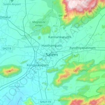
Name: Salem topographic map, elevation, terrain.
Location: Salem, Salem District, Tamil Nadu, India (11.53745 78.11011 11.78369 78.31861)
Average elevation: 400 m
Minimum elevation: 230 m
Maximum elevation: 1,456 m
Make a donation
Other topographic maps
Click on a map to view its topography, its elevation and its terrain.
Auroville
India > Tamil Nadu > Vanur
It is included in the sub-humid tropics (wet-and-dry tropical climate) situated on a plateau region with its maximum elevation of 32 m (105 ft) above sea level located in the Matrimandir area. The annual rainfall average is 1,200 mm (47 in) mainly from the SW monsoon (June to Sept.) and NE monsoon (Nov to Dec)…
Average elevation: 36 m