
Thank you for supporting this site ❤️
Make a donation
Make a donation
Istanbul topographic map
Click on the map to display elevation.
Thank you for supporting this site ❤️
Make a donation
Make a donation
About this map
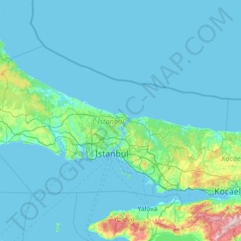
Name: Istanbul topographic map, elevation, terrain.
Location: Istanbul, Marmara Region, Turkey (40.73767 27.97085 41.67100 29.95880)
Average elevation: 74 m
Minimum elevation: -4 m
Maximum elevation: 1,343 m
Thank you for supporting this site ❤️
Make a donation
Make a donation
Other topographic maps
Click on a map to view its topography, its elevation and its terrain.