
Thank you for supporting this site ❤️
Make a donation
Make a donation
Oyo State topographic map
Click on the map to display elevation.
Thank you for supporting this site ❤️
Make a donation
Make a donation
About this map
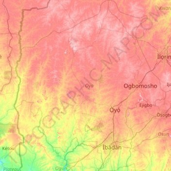
Name: Oyo State topographic map, elevation, terrain.
Location: Oyo State, Nigeria (7.08010 2.67693 9.18831 4.56900)
Average elevation: 271 m
Minimum elevation: 16 m
Maximum elevation: 599 m
Thank you for supporting this site ❤️
Make a donation
Make a donation
Other topographic maps
Click on a map to view its topography, its elevation and its terrain.