
Make a donation
Flemington topographic map
Click on the map to display elevation.
Make a donation
About this map
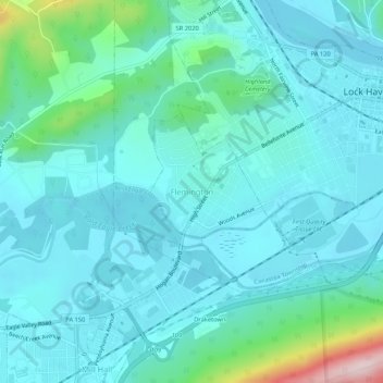
Name: Flemington topographic map, elevation, terrain.
Location: Flemington, Clinton County, Pennsylvania, United States (41.10646 -77.49165 41.14646 -77.45165)
Average elevation: 212 m
Minimum elevation: 157 m
Maximum elevation: 517 m
Make a donation
Other topographic maps
Click on a map to view its topography, its elevation and its terrain.
Nittany Valley
United States > Pennsylvania > Clinton County > Porter Township
Nittany Valley is in the western part of the Ridge and Valley province of the Appalachian Mountains. During the Appalachian orogeny, the sedimentary rock layers folded up into the Nittany Arch anticline. The arch was an ancient Himalayan scale mountain that towered above what is now the valley. The oldest rock…
Average elevation: 362 m
Beech Creek
United States > Pennsylvania > Clinton County > Beech Creek Township
Average elevation: 359 m
Make a donation
Make a donation
Canastea Township
United States > Pennsylvania > Clinton County > Canastea Township
Average elevation: 276 m
Make a donation