
Río Apure topographic map
Interactive map
Click on the map to display elevation.
About this map
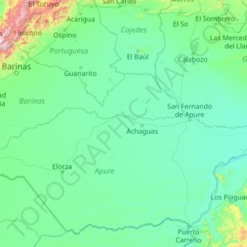
Name: Río Apure topographic map, elevation, terrain.
Location: Río Apure, Municipio Achaguas, Apure, 7001, Venezuela (7.57311 -70.32820 8.06996 -66.39886)
Average elevation: 158 m
Minimum elevation: 21 m
Maximum elevation: 3,621 m
Other topographic maps
Click on a map to view its topography, its elevation and its terrain.
San Fernando de Apure
Venezuela > Apure > Municipio San Fernando
San Fernando de Apure, Parroquia Urbana San Fernando, Municipio San Fernando, Apure, 7001, Venezuela
Average elevation: 45 m