
Make a donation
Lehfed topographic map
Click on the map to display elevation.
Make a donation
Lehfed
Lehfed (Arabic: لحفد, also known as Lihfid) is a municipality in the Byblos District of Keserwan-Jbeil Governorate, Lebanon. It is 55 kilometers north of Beirut. Lehfed has an average elevation of 1000 meters above sea level and a total land area of 542 hectares. There were three companies with more than five employees operating in the village as of 2008. Its population, consisting of 2400 inhabitants, 950 of them being electors, is predominantly Maronite Catholic. Lehfed is the hometown of the Blessed Stephen Nehmé.
Make a donation
About this map
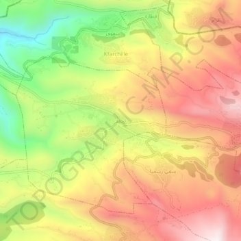
Name: Lehfed topographic map, elevation, terrain.
Location: Lehfed, Jbeil District, Keserwan-Jbeil Governorate, Lebanon (34.14709 35.75988 34.18709 35.79988)
Average elevation: 1,049 m
Minimum elevation: 620 m
Maximum elevation: 1,401 m
Make a donation
Other topographic maps
Click on a map to view its topography, its elevation and its terrain.
Make a donation
Make a donation
Faytroun
Lebanon > Keserwan-Jbeil Governorate
Faitroun (Arabic: فيطرون, romanized: Fayṭrūn; also spelled Faytroun) is a town in the Keserwan District of Keserwan-Jbeil Governorate. Located 33 kilometers north of Beirut and at an average altitude of 1,200 meters above sea level and its total land area of 743 hectares. Its inhabitants are…
Average elevation: 1,207 m
Make a donation
Make a donation
Make a donation
Make a donation
Make a donation
Mounsef
Lebanon > Keserwan-Jbeil Governorate
Mounsef (Arabic: المنصف, also spelled al-Mounsif) is a municipality in the Byblos District of Keserwan-Jbeil Governorate, Lebanon. It located off the Mediterranean coast and is 47 kilometers north of Beirut. Mounsef has an average elevation of 220 meters above sea level and a total land area of 341…
Average elevation: 127 m
Make a donation
Zouk Mosbeh
Lebanon > Keserwan-Jbeil Governorate
Zouk Mosbeh (Arabic: زوق مصبح) is a town and municipality in the Keserwan District of the Keserwan-Jbeil Governorate in Lebanon. It is located 12 kilometers north of Beirut. Zouk Mosbeh's average elevation is 170 meters above sea level and its total land area is 453 hectares. Its inhabitants are…
Average elevation: 114 m
Make a donation
Make a donation
Make a donation
Make a donation
Make a donation
Make a donation
Ghazir
Lebanon > Keserwan-Jbeil Governorate
Ghazir (Arabic: غزير) is a town and municipality in the Keserwan District of the Keserwan-Jbeil Governorate of Lebanon. It is located 27 kilometres (17 mi) north of Beirut. It has an average elevation of 380 meters above sea level and a total land area of 542 hectares (2.09 sq mi). The town has four…
Average elevation: 359 m
Make a donation