
Make a donation
Mato topographic map
Click on the map to display elevation.
Make a donation
Mato
The district is located in the west-central part of the province at an elevation of 2,239m in the black mountains (Spanish: Cordillera Negra), neighboring district is the Caraz district in which the provinces capital Caraz is located, 12 km from the village of Villa Sucre. The regions capital Huaraz is located at 79 km from Villa Sucre.
Make a donation
About this map
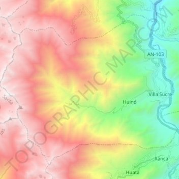
Name: Mato topographic map, elevation, terrain.
Location: Mato, Province of Huaylas, Ancash, Peru (-9.01091 -77.95572 -8.90626 -77.82942)
Average elevation: 3,455 m
Minimum elevation: 1,902 m
Maximum elevation: 5,030 m
Make a donation
Other topographic maps
Click on a map to view its topography, its elevation and its terrain.
Laguna Palcacocha
Peru > Ancash > Independencia
Palcacocha is located at 9°23′49″S 77°22′47″W / 9.39694°S 77.37972°W / -9.39694; -77.37972 in the Ancash Region in Cordillera Blanca at an elevation of 4,566 m, just below the summits of Palcaraju (6,274 m) and Pucaranra (6,156 m). The lake is one of several lakes supplying the town Huaraz…
Average elevation: 4,857 m
Make a donation
Viewpoint crack in mountains shaped like the map of Peru
Average elevation: 4,202 m
Make a donation
Make a donation
Make a donation
Jirishanca
The altitude of 6125 isn't likely as other data from available digital elevation models show lower elevations: SRTM yields 6028 metres and TanDEM-X 5734 metres. The height of the nearest key col is 5610 meters, leading to a topographic prominence of 484 meters. Jirishanca is considered a Mountain according to…
Average elevation: 5,198 m
Make a donation
Make a donation
Make a donation
Make a donation