
Cheddar topographic map
Interactive map
Click on the map to display elevation.
About this map
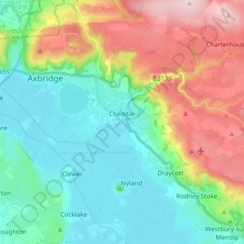
Name: Cheddar topographic map, elevation, terrain.
Location: Cheddar, Somerset, England, Vereinigtes Königreich (51.23585 -2.83912 51.30903 -2.70989)
Average elevation: 109 m
Minimum elevation: 3 m
Maximum elevation: 325 m
Other topographic maps
Click on a map to view its topography, its elevation and its terrain.
Bridgwater
Vereinigtes Königreich > England > Somerset
Bridgwater, Somerset, England, Vereinigtes Königreich
Average elevation: 10 m
Bossington Hill
Vereinigtes Königreich > England > Somerset > Allerford > Selworthy
Bossington Hill, Bossington Lane, Allerford, Selworthy, Allerford, Somerset, England, TA24 8HN, Vereinigtes Königreich
Average elevation: 89 m
Wells
Vereinigtes Königreich > England > Somerset > Mendip
Wells, Mendip, Somerset, Südwestengland, England, Vereinigtes Königreich
Average elevation: 68 m