
Les Travers topographic map
Interactive map
Click on the map to display elevation.
About this map
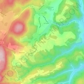
Name: Les Travers topographic map, elevation, terrain.
Average elevation: 537 m
Minimum elevation: 400 m
Maximum elevation: 708 m
Other topographic maps
Click on a map to view its topography, its elevation and its terrain.
Chevigny
France > Bourgogne-Franche-Comté > Nièvre > Moux-en-Morvan
Chevigny, Moux-en-Morvan, Château-Chinon (Ville), Nièvre, Bourgogne-Franche-Comté, France métropolitaine, 58230, France
Average elevation: 603 m
Montsermage
France > Bourgogne-Franche-Comté > Nièvre > Moux-en-Morvan > Montsermage
Montsermage, Moux-en-Morvan, Château-Chinon (Ville), Nièvre, Bourgogne-Franche-Comté, France métropolitaine, 58230, France
Average elevation: 621 m
Le Cerney
France > Bourgogne-Franche-Comté > Nièvre > Moux-en-Morvan
Le Cerney, Moux-en-Morvan, Château-Chinon (Ville), Nièvre, Bourgogne-Franche-Comté, France métropolitaine, 58230, France
Average elevation: 612 m