
Aklan topographic map
Interactive map
Click on the map to display elevation.
Aklan
Mount Nausang, is the previous highest peak in Aklan, standing at 5,138 ft (1,566 m), but Mount Madi-ac is higher, with an elevation of 1,716 m (5,630 ft) above sea level, located 6 km northwest of Mount Nausang and 4.8 km northeast of Mount Madja-as. Aklan River, is the longest river in the province with a total length of 91 km (57 mi) long.
About this map
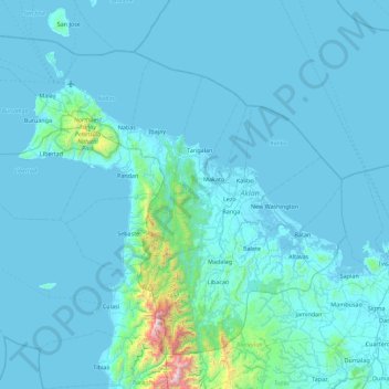
Name: Aklan topographic map, elevation, terrain.
Location: Aklan, Western Visayas, Philippines (11.31761 121.70414 12.03639 122.59750)
Average elevation: 94 m
Minimum elevation: -3 m
Maximum elevation: 2,023 m
Other topographic maps
Click on a map to view its topography, its elevation and its terrain.