
Abdullapurmet mandal topographic map
Interactive map
Click on the map to display elevation.
About this map
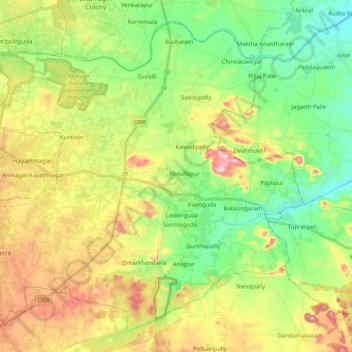
Name: Abdullapurmet mandal topographic map, elevation, terrain.
Location: Abdullapurmet mandal, Rangareddy, Telangana, India (17.23433 78.55832 17.40467 78.76265)
Average elevation: 478 m
Minimum elevation: 383 m
Maximum elevation: 627 m
Other topographic maps
Click on a map to view its topography, its elevation and its terrain.
Batasingaram
India > Telangana > Abdullapurmet mandal
Batasingaram, Abdullapurmet mandal, Ranga Reddy District, Telangana, India
Average elevation: 444 m