
East End topographic map
Interactive map
Click on the map to display elevation.
About this map
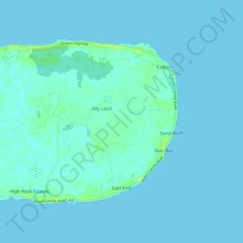
Name: East End topographic map, elevation, terrain.
Location: East End, Cayman Islands (19.29233 -81.18207 19.35516 -81.08468)
Average elevation: 2 m
Minimum elevation: 0 m
Maximum elevation: 16 m
Other topographic maps
Click on a map to view its topography, its elevation and its terrain.
Little Cayman
Little Cayman is one of three Islands that make up the Cayman Islands. It is located in the Caribbean Sea, approximately 60 miles (96 km) northeast of East End, Grand Cayman and five miles (8 km) west of West End, Cayman Brac. Little Cayman is the least populous island of the three, with a permanent population…
Average elevation: 1 m