
Le Grand Heu topographic map
Interactive map
Click on the map to display elevation.
About this map
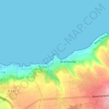
Name: Le Grand Heu topographic map, elevation, terrain.
Average elevation: 39 m
Minimum elevation: -1 m
Maximum elevation: 153 m
Other topographic maps
Click on a map to view its topography, its elevation and its terrain.
Le Hardelle
France > Normandie > Manche > Bretteville
Le Hardelle, Bretteville, Cherbourg, Manche, Normandie, France métropolitaine, 50110, France
Average elevation: 50 m
Hameau des Cordeliers
France > Normandie > Manche > Bretteville
Hameau des Cordeliers, Bretteville, Cherbourg, Manche, Normandie, France métropolitaine, 50110, France
Average elevation: 78 m