
Make a donation
Wuhai City topographic map
Click on the map to display elevation.
Make a donation
Wuhai City
Wuhai is situated in western Inner Mongolia, in the upper reaches of the Yellow River, which flows through the city. The western bank of the river is Wuda District, while the eastern bank includes Haibowan District and Hainan District. The city borders Ordos City in Inner Mongolia to the east and north, Shizuishan City in Ningxia to the south, and the Alxa League of Inner Mongolia to the west. Located in a transitional zone between desertified grasslands and grassland-desert ecosystems, Wuhai has an average elevation of 1,150 meters.
Make a donation
About this map
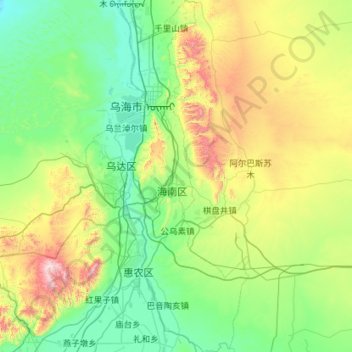
Name: Wuhai City topographic map, elevation, terrain.
Location: Wuhai City, Inner Mongolia, China (39.03548 106.60447 39.91526 107.13382)
Average elevation: 1,326 m
Minimum elevation: 1,036 m
Maximum elevation: 2,395 m
Make a donation
Other topographic maps
Click on a map to view its topography, its elevation and its terrain.
Make a donation
Make a donation
Make a donation
Make a donation
Make a donation
Make a donation
Horqin Right Front Banner
China > Inner Mongolia > Horqin Right Front Banner > Ke'erqin
Average elevation: 348 m
Make a donation