
Villepot topographic map
Interactive map
Click on the map to display elevation.
About this map
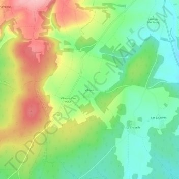
Name: Villepot topographic map, elevation, terrain.
Average elevation: 268 m
Minimum elevation: 200 m
Maximum elevation: 366 m
Other topographic maps
Click on a map to view its topography, its elevation and its terrain.
La Porte de Fouronnes
France > Bourgogne-Franche-Comté > Yonne > Courson-les-Carrières
La Porte de Fouronnes, Courson-les-Carrières, Auxerre, Yonne, Bourgogne-Franche-Comté, France métropolitaine, 89560, France
Average elevation: 252 m
Laurent
France > Bourgogne-Franche-Comté > Yonne > Courson-les-Carrières > Les Laurents
Laurent, Les Laurents, Courson-les-Carrières, Auxerre, Yonne, Bourgogne-Franche-Comté, France métropolitaine, 89560, France
Average elevation: 232 m