
Waquoit Bay topographic map
Interactive map
Click on the map to display elevation.
About this map
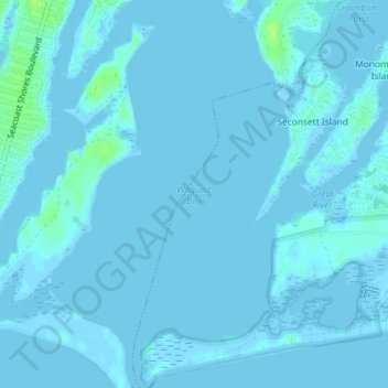
Name: Waquoit Bay topographic map, elevation, terrain.
Average elevation: 1 m
Minimum elevation: -2 m
Maximum elevation: 10 m
Other topographic maps
Click on a map to view its topography, its elevation and its terrain.
Santuit Pond
United States > Massachusetts > Barnstable County > Mashpee > Mashpee Neck > Pine Tree Corner
Santuit Pond, Pine Tree Corner, Mashpee Neck, Mashpee, Barnstable County, Massachusetts, United States
Average elevation: 15 m
Mashpee Neck
United States > Massachusetts > Barnstable County > Mashpee > Mashpee Neck
Mashpee Neck, Mashpee, Barnstable County, Massachusetts, 02365, United States
Average elevation: 10 m