
Thank you for supporting this site ❤️
Make a donation
Make a donation
Alachua topographic map
Click on the map to display elevation.
Thank you for supporting this site ❤️
Make a donation
Make a donation
About this map
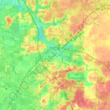
Name: Alachua topographic map, elevation, terrain.
Location: Alachua, Alachua County, Florida, United States (29.71842 -82.55577 29.84002 -82.38163)
Average elevation: 39 m
Minimum elevation: 13 m
Maximum elevation: 63 m
Thank you for supporting this site ❤️
Make a donation
Make a donation
Other topographic maps
Click on a map to view its topography, its elevation and its terrain.